 3 year ago
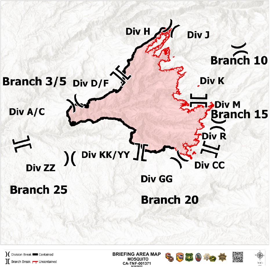
MosquitoFire briefing map for Sunday (9/18) shows black line from Bacchi Ranch Rd. to Westville: the entire western perimeter of the fire
Earthquake of magnitude 4.6 - south of the Fiji Islands
Earthquake of magnitude 5.0 - Ryukyu Islands, Japan
Taipei, Sept. 18 (CNA) A magnitude 6.8 earthquake struck Taiwan's southeastern Taitung County at 2:44 p.m. Sunday. The opening level of The Central Emergency Operating Center (CEOC) is 1 now.
Earthquake of magnitude 5.5 - 170 km W of Lata, Solomon Islands
Earthquake of magnitude 5.5 - 82 km SE of Lugu, Taiwan
3.4 magnitude earthquake. 14 mi from Thermal, CA, United States
A magnitude 6.8 earthquake caused a three-story building in Hualien County's Yuli Township in eastern Taiwan to collapse Sunday afternoon, with local police saying they were still searching for three people trapped in the rubble
Earthquake of magnitude 5.2 - 86 km E of Yujing, Taiwan
Earthquake of magnitude 5.7 - 166 km W of Itoman, Japan
Earthquake of magnitude 5.2 - Ryukyu Islands, Japan
5.1 magnitude earthquake. 37 km from Taitung City, Taiwan, Taiwan
The earthquake was over land, but the @NWS_NTWC confirms there's no tsunami threat to the USA
3.5 magnitude earthquake. 14 mi from Thermal, CA, United States
7.2 magnitude earthquake. 41 km from Taitung City, Taiwan, Taiwan
Earthquake of magnitude 5.1 - 79 km E of Yujing, Taiwan
7.2 magnitude earthquake. 41 km from Taitung City, Taiwan, Taiwan
5.2 magnitude earthquake. 41 km from TaitungCity, Taiwan, Taiwan
Earthquake of magnitude 7.2 - 86 km E of Yujing, Taiwan
Earthquake of magnitude 7.2 - 81 km E of Yujing, Taiwan
Earthquake of magnitude 5.2 - 87 km E of Yujing, Taiwan
2.5 magnitude earthquake. 14 mi from Thermal, CA, United States
Earthquake of magnitude 4.9 - 171 km W of Itoman, Japan
2.6 magnitude earthquake. 14 mi from Thermal, CA, UnitedStates
Earthquake of magnitude 5.6 - 83 km E of Yujing, Taiwan
MosquitoFire - USFS has got Copter 531 from Angeles NF up @ the fire for night time water dropping ops. Big increase in winds today, 20-25mph gusts out of S/W. Radio traffic said they're expecting showers starting around 1am. Placer Co just downgraded evacs for Zone 12
MosquitoFire (Foresthill, Placer Co/El Dorado Co) - 73,381 acres, 21% contained, 3,729 personnel assigned. Long story short: mopping up the western side of the fire still. Eastern side: didn't move much today, just looked very impressive with some large pockets of heat
Earthquake of magnitude 4.6 - Mid-Indian Ridge
Earthquake of magnitude 4.8 - near the east coast of Honshu, Japan
Earthquake of magnitude 4.6 - 96 km E of Yujing, Taiwan
Earthquake of magnitude 4.7 - 97 km E of Yujing, Taiwan
Earthquake of magnitude 4.9 - southern Mid-Atlantic Ridge
Tornado Warning including Villisca IA, Stanton IA and Coburg IA until 8:15 PM CDT
Earthquake of magnitude 4.8 - 189 km ESE of Kokopo, Papua New Guinea
Earthquake of magnitude 4.9 - Pagan region, Northern Mariana Islands
Earthquake of magnitude 4.6 - 89 km E of Yujing, Taiwan
Earthquake of magnitude 4.7 - 81 km E of Yujing, Taiwan
Earthquake of magnitude 5.5 - 79 km ESE of Yujing, Taiwan
Earthquake of magnitude 5.1 - 79 km E of Yujing, Taiwan
Earthquake of magnitude 5.1 - 104 km E of Iquique, Chile
Earthquake of magnitude 6.6 - 76 km E of Yujing, Taiwan
Earthquake of magnitude 6.6 - 91 km E of Yujing, Taiwan
Earthquake of magnitude 4.6 - Tarapaca, Chile
2.7 magnitude earthquake. 71 km from Cascade, ID, United States
2.7 magnitude earthquake. 17 mi from China Lake Acres, CA, United States
Earthquake of magnitude 5.1 - 128 km SW of Labuan, Indonesia
Earthquake of magnitude 5.2 - south of Africa
Vegetation Fire in Jurupa Valley RPT @ 8:22 PM - Clay St / Limonite Ave . Firefighters are on scene, 2-3 acres involved.
1.5-2 acres, starting to make progress, continued structure threat with structure defense in place, hose lay being tied in. Canceling the request for 5 additional engines
LimoniteFire in JurupaValley, Riverside Co: 2-3 acres within the old burn from earlier this year, west wind on it pushing east, immediate structure threat to the convalescent home again. Total of 15 addl engines requested. El Palomino Dr & Limonite Ave
IC reporting 2-3 Acres within a burn scar, heavy Vegetation, fire being pushed by west wind, structure threat. Division Alpha and Division Zulu has been established. 1 additional Chief Officer requested to the scene
Earthquake of magnitude 4.9 - Mid-Indian Ridge
The MosquitoFire has burned 71,292 acres across Placer and El Dorado Counties and remains at 20% containment. 73 structures have been destroyed, and 13 structures have been damaged as a result of the fire across both counties. Approx 9,236 homes remain threatened due to the fire
MosquitoFire - They don't have any concerns regarding the communities of Quintette, Volcanoville, Todd Valley, Foresthill, Georgetown & further south, as wind won't be in alignment + the firefighting & control efforts have been fantastic in these areas
MosquitoFire - Fire activity generally remains active on the entire eastern front. Winds increase out of the S/W tomorrow around 11am & picking up even more so at 3pm, in advance of the storm system on Saturday night
MosquitoFire (Foresthill, Placer Co/El Dorado Co) - 71,292 acres, 20% contained, 3,453 personnel assigned. Firing operation along the MFAR (Todd Valley/Buckeye Point) has gone well, still some interior pockets of fuels burning & producing smoke, it's expected
FairviewFire off Fairview Avenue and Bautista Canyon Road, near Hemet in Riverside County is 28,307 acres and is 97% contained