Earthquake of magnitude 4.8 - south of the Fiji Islands
Earthquake of magnitude 4.6 - Pulau-Pulau Talaud, Indonesia
Earthquake of magnitude 5.0 - Banda Sea
Earthquake of magnitude 4.6 - Reykjanes Ridge
Earthquake of magnitude 4.6 - Reykjanes Ridge
Earthquake of magnitude 5.0 - 29 km WSW of Ovalle, Chile
Earthquake of magnitude 4.7 - 7 km ENE of Jordán, Colombia
 2 year ago
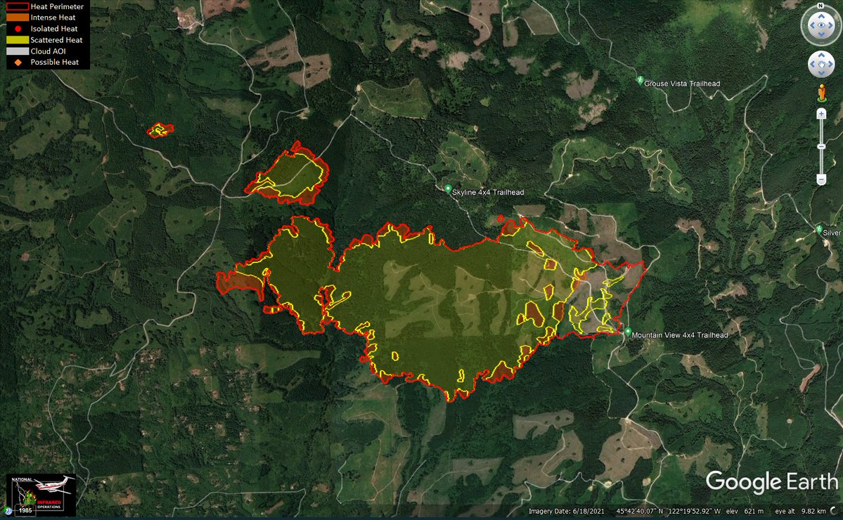
NakiaCreekFire in Clark Co, WA: It got mapped at 1,796 acres just before 7pm, +231 acres today. Both of the spot fires grew slightly, as did the far west end of main fire. No real advancement towards the structures off NE 94th St. Red = intense heat, yellow = scattered heat
Earthquake of magnitude 4.9 - 42 km SSE of Calingasta, Argentina
Tornado Warning including Fort Pierce FL, Lakewood Park FL and Saint Lucie FL until 8:45 PM EDT
Earthquake of magnitude 4.6 - 20 km SE of San Jorge, Nicaragua
Tornado Warning including Lakewood Park FL, Oslo FL and Indrio FL until 7:15 PM EDT
Earthquake of magnitude 4.9 - Pagan region, Northern Mariana Islands
Earthquake of magnitude 4.6 - Revilla Gigedo Islands region
Gorman. Brush fire. 5 freeway at Gorman Rd. HenryFire. LACoFD E477 reports this is 3 miles south of the exit. 50 x 100 start running in grass with multiple starts. No structures threatened
Gorman. Brush fire. 5 freeway at Gorman Rd. HenryFire. Communications Plan: Admin Blue 11. Command V-5. Primary Tac V-8. Secondary Tac V-12. A/G LACo A/G. Crewith Dozer U14. Victor 130
Gorman. Brush fire. 5 freeway at Gorman Rd. HenryFire. IC updates to 6 starts along the 5 freeway. Keeping all units including aircraft
Gorman. Brush fire. 5 freeway at Gorman Rd. HenryFire. IC wants CHP to investigate north and south along the 5 for any additional starts
According to CRESA: 2900 homes are under Level 3 evacuation orders (leave now) due to the NakiaCreekFire . Around 40,000 homes are under some kind of evacuation order in Clark Co. Fire is burning nearly 1600 acres
Earthquake of magnitude 4.7 - south of Africa
Earthquake of magnitude 5.2 - 94 km SE of Palca, Peru
Earthquake of magnitude 5.1 - 81 km SE of Hengchun, Taiwan
Earthquake of magnitude 5.0 - 72 km SE of Gorontalo, Indonesia
Earthquake of magnitude 4.8 - 157 km ESE of Kokopo, Papua New Guinea
Earthquake of magnitude 4.7 - western Xizang
Earthquake of magnitude 5.1 - 179 km E of Amahai, Indonesia
NakiaCreekFire: At time of mapping it was about .4 to .6 of a mile from the closest structures at the end of NE 94th St east of L-1600.
Starting with the NakiaCreekFire in Clark County: it got mapped at 1,565 acres this evening, likely around 7-8pm, no exact time due to no accompanying log file at this time
 2 year ago
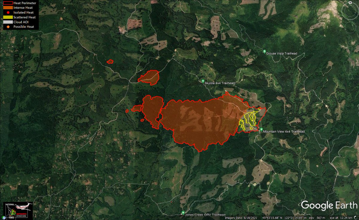
NakiaCreekFire: All of the spread appears to have been to the west, W/NW. Red = intense heat, yellow = scattered heat. Notable areas of heat well outside the main fire area. The furthermost N/W spot is 1.25 miles from the main fire
3.0 magnitude earthquake. 2 mi from Aguanga, CA, United States