 3 year ago
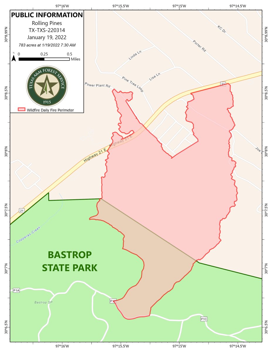
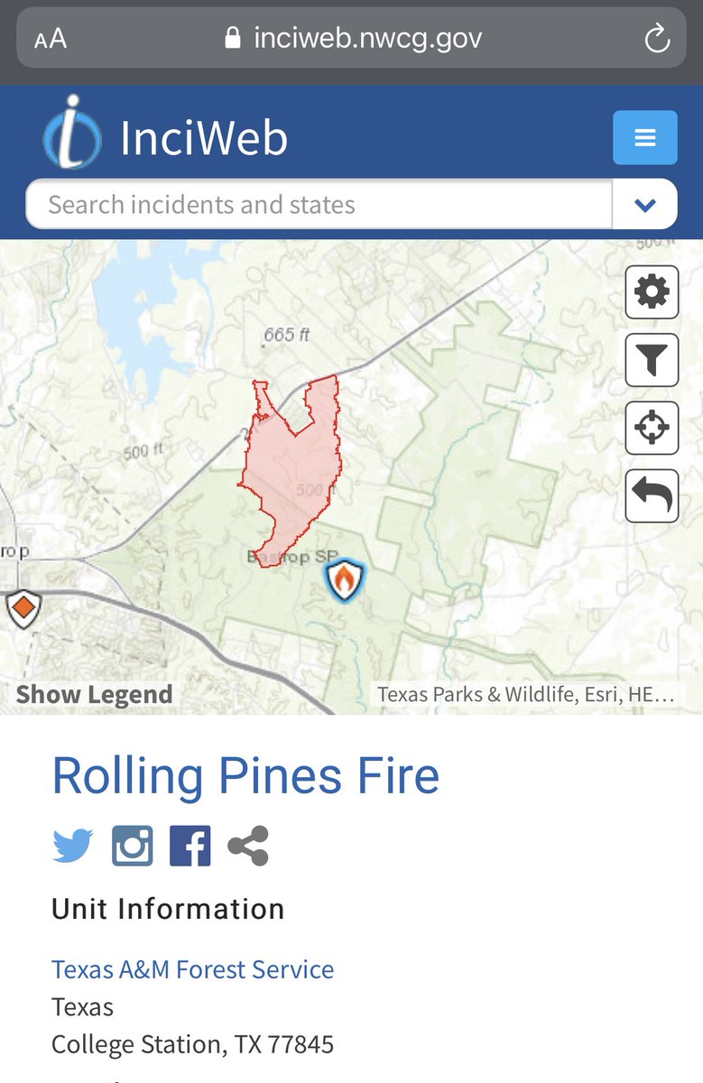
Public information map for the RollingPinesFire in Bastrop County showing 783 acres as of January 19, 2022
Earthquake of magnitude 4.9 - 174 km ENE of Katabu, Indonesia
 3 year ago
Rolling Pines Fire UpdateJanuary 19, 20229:00 amSize: 783 acresContainment: 30%
Earthquake of magnitude 4.7 - 82 km NNW of Bima, Indonesia
 3 year ago
Rolling Pines Fire grows to 783 acres and containment increases to 30%. from Bastrop County Office of Emergency Management
Earthquake of magnitude 5.5 - 219 km E of Amahai, Indonesia
 3 year ago
RollingPinesFire: @RemadnaKXAN says this morning there's no visible smoke, flames or even smell of smoke in Bastrop County - Hwy 21 still shutdown - At last check, 500 acres burned. 10% contained - 250 families evacuated
 3 year ago
RollingPinesFire has tamed with much lighter winds as compared to a few hours ago. Fire fighters able to attack from close range now. No update on containment. SH21 remains closed from FM1441 to South Shore Road
Earthquake of magnitude 4.6 - 21 km NW of Dogonbadan, Iran
Earthquake of magnitude 5.4 - southwest of Africa
Earthquake of magnitude 4.6 - 16 km WNW of Yopal, Colombia
Earthquake of magnitude 4.8 - 45 km N of Güiria, Venezuela
 3 year ago
wildfire near Bastrop. Texas A&M forest service tells: "The fire is currently being held south and east of Powerline road. No fire has entered circle d estates. Engines and bull dozers are continuing to work on increasing containment.
Earthquake of magnitude 4.6 - 96 km NE of Nanortalik, Greenland
Earthquake of magnitude 4.6 - south of the Kermadec Islands
Earthquake of magnitude 4.8 - 36 km NNW of Nuku‘alofa, Tonga
Earthquake of magnitude 5.0 - 86 km N of Basco, Philippines
Earthquake of magnitude 5.2 - Pacific-Antarctic Ridge
Earthquake of magnitude 4.9 - 68 km NW of Nuku‘alofa, Tonga
Earthquake of magnitude 5.0 - west of Macquarie Island
 3 year ago
Meanwhile in Saudi Arabia: Caravan of Camels travels in a rare snowy desert near Tabuk. Northwestern region of country seeing heavy snows/storms
Earthquake of magnitude 5.0 - 94 km NW of Kandrian, Papua New Guinea
Earthquake of magnitude 4.7 - Izu Islands, Japan region
Earthquake of magnitude 4.8 - 266 km WNW of Pangai, Tonga
 3 year ago
Indian Army rescues 30 civilians during avalanches near Sadhna Pass in Tangdhar of North Kashmir. 12 vehicles were also later retrieved and snow clearance operations conducted in dangerous conditions. Entire effort took about five to six hours. Kudos to the forces
3.7 magnitude earthquake. 62 km from Kodiak, AK, United States
 3 year ago
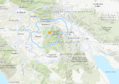
USGS reports a 3.5 magnitude earthquake occurred at 11:39 Monday night 6 miles northwest of Idyllwild in Riverside County. Map from United States Geological Survey
3.7 magnitude earthquake. 6 mi from Idyllwild-Pine Cove, CA, UnitedStates
2.7 magnitude earthquake. 14 mi from Lompoc, CA, United States
Earthquake of magnitude 4.6 - 53 km SSE of El Coyul, Mexico